

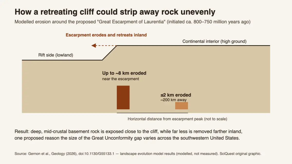
The Grand Canyon holds about two billion years of Earth history, yet more than half of that record is missing at a buried erosion surface called the Great Unconformity. A team led by Thomas Gernon of the University of Southampton now proposes a culprit for the canyon region: a continent-scale cliff, the “Great Escarpment of Laurentia”, that eroded and retreated inland after Rodinia began to split. Published in Geology, the idea rests on plate reconstructions and computer models, not new rock dating, and it competes with other explanations, including erosion by Snowball Earth glaciers.
What you need to know
- Finding: The authors argue that rock removal beneath the Great Unconformity in the Grand Canyon region was focused along a giant rift-flank escarpment that began forming around 800–750 million years ago.
- Method: Plate tectonic reconstructions combined with landscape evolution models that simulate how rift-driven topography erodes over time.
- Source: Gernon and colleagues, “Exhumation of Grand Canyon’s basement along the Great Escarpment of Laurentia,” Geology, published online 17 August 2026.
- Why it matters: A retreating cliff predicts patchy erosion, which could explain why the amount of missing rock varies so much across the southwestern United States.
- Limitation: The escarpment itself has been eroded away; its existence and erosion totals are inferred from models and earlier thermochronology, not observed directly.
Is this a big deal?
It is a solid, testable proposal rather than a solved mystery. The Great Unconformity has resisted a single explanation for more than a century, and this paper adds a specific mechanism that predicts where erosion should be deepest. Its value lies in that prediction: geologists can now check whether rocks near the reconstructed cliff line really lost more cover than rocks farther inland.
What scientists found
An unconformity is a surface where younger rock sits directly on much older rock, with the rocks of the time in between eroded or never deposited. In the Grand Canyon, much younger layered rock rests directly on ancient crystalline “basement” rock. The gap in between can exceed a billion years.
The size of that gap depends on where you stand, which is exactly what the new study tries to explain. In parts of the canyon a tilted wedge of younger Precambrian rock, the Grand Canyon Supergroup, survives between the basement and the flat-lying layers above, splitting the missing time into two smaller gaps. Where the Supergroup was eroded away, the full gap opens up.
| Contact | Rock below | Rock above | Missing time |
|---|---|---|---|
| Great Unconformity | Vishnu basement, about 1.75 billion years old | Cambrian sandstone, about 505–510 million years old | About 1.2 billion years |
| Great Nonconformity | Vishnu basement | Base of the Grand Canyon Supergroup, about 1.25 billion years old | Up to about 500 million years |
| Great Angular Unconformity | Tilted Supergroup layers, 1.25–1.1 billion years old (Unkar Group) | Cambrian sandstone | Up to about 750 million years |
Source: National Park Service, “Grand Canyon Time: Missing Time”. Ages are rounded; the NPS gives slightly different figures in different figure captions. Table compiled by SciQuest.
The escarpment model concerns the last of these episodes: erosion between about 800 million years ago and the arrival of the Cambrian sea, which removed Supergroup rock in some places and cut into the basement in others.
The new paper argues that much of the erosion in this region happened along one landform. As Rodinia rifted (a process driven by plate tectonics, one of the traits that makes a planet Earth-like), the edge of ancestral North America (geologists call it Laurentia) was lifted, creating a high plateau that dropped sharply toward the rift. The authors call this step the Great Escarpment of Laurentia and compare it with the great escarpments left behind when Gondwana broke apart in the Mesozoic. The Southampton release describes the cliffs as kilometre-high and running thousands of kilometres, potentially across areas that are now Arizona, Utah, Idaho, Wyoming, Colorado, Texas, Oklahoma, Arkansas, Missouri and Illinois.
How they found it
The team did not find a fossil cliff. Instead, they placed North America in plate reconstructions of Rodinia’s breakup, then ran landscape evolution models, computer simulations of how uplift, rivers and slopes wear land down over millions of years.
In the models, rocks within several hundred kilometres of the escarpment were heavily eroded: up to about 8 km near the escarpment, tapering to 2 km or less roughly 200 km from its peak. According to the university’s release, the reconstruction places the Grand Canyon in the same position relative to the old continental edge as the great escarpments of South Africa and Brazil sit today relative to the South Atlantic. Those cliffs also began as the raised shoulders of a rift, then retreated inland as rivers wore them back. The release says the Laurentian escarpment retreated over tens of millions of years.
The authors note that this kind of uneven erosion matches earlier thermochronology, a technique that reads a rock’s cooling history to estimate when it rose toward the surface. The paper argues that erosion on this scale, together with movement on reactivated faults in the crust, is needed to explain how basement rock from the middle of the crust was brought up toward the surface. The release adds that independent evidence already pointed to some 5 to 10 km of erosion in the region long before the modern canyon formed, so the model’s 8 km figure sits inside a range geologists had reached by other means.
“Our work suggests that tectonic uplift related to continental rifting and breakup created both steep slopes and high ground, providing the mountainous terrain that rivers and glaciers could readily erode,” Gernon said in the university’s statement. That wording matters: the escarpment idea does not rule glaciers out. It gives them, and rivers, high ground to attack.
Why it matters to you
Nothing here affects daily life. The payoff is understanding. Hike to the canyon floor and you cross a contact where more than a billion years of history is missing, and this study suggests a vanished cliff line, rather than one global event, may be the reason. If that holds up, geologists will read gaps in rock records elsewhere differently, along with the ground that existed just before complex animals appeared in the Cambrian.
What the evidence does not show
The paper does not prove that the escarpment existed. Its height, length and exact route are reconstructed. The 8 km figure is a model output for the most heavily eroded zone, not a measurement at any one outcrop.
The study is also regional. It addresses the variable erosion beneath the Great Unconformity in the southwestern United States, and does not claim to explain every unconformity worldwide. According to IFLScience’s report, the authors see their mechanism as compatible with other processes acting alongside it.
How this fits what we already knew
The paper itself notes that the Great Unconformity has been linked both to multi-phase tectonics during supercontinent assembly and breakup and to glacial erosion during the Cryogenian, the “Snowball Earth” period. Two earlier studies frame that debate:
- Glacial erosion: In a paper published online at the end of 2018, Keller and colleagues argued in PNAS that zircon isotope signals point to a late Neoproterozoic erosion event of unprecedented scale, consistent with erosion by Snowball Earth glaciers.
- Several regional unconformities: In 2020, Flowers and colleagues reported in PNAS that most erosion beneath the Great Unconformity in Colorado happened before Cryogenian glaciation, and suggested multiple regional, tectonic Great Unconformities formed at different times.
The new escarpment model sits closer to the tectonic camp. Rift uplift has long been blamed; the new step is concentrating that erosion along a single retreating cliff. For background on what lies beneath the surface rocks, see our guide to the layers of Earth.
Independent expert view
We did not find on-the-record comment from independent geologists in the coverage we reviewed, and SciQuest has not yet obtained one. The 2018 and 2020 studies above show that specialists have reached different conclusions about timing and cause, so this proposal should be read as one entry in a live debate.
How other headlines framed it
- IFLScience led with the scale of the “mega-escarpment” and was the most explicit about competing glacial ideas.
- Interesting Engineering focused on the roughly 1 km cliff and noted that the result rests on reconstructions and models.
- The Debrief framed it around timing, implying the canyon itself formed far earlier. That is a stretch: the study concerns exposure of the basement rocks, while the canyon was carved much later by the Colorado River.
- Courthouse News called it a discovery that may explain the missing billion years.
What happens next
The model makes a map-like prediction: erosion should be deepest close to the reconstructed escarpment and shallower inland. New thermochronology and sediment-source studies across the states the cliff may have crossed could support or undercut it. The authors also suggest the escarpment may have steered rivers, sediment and later sea flooding before the Cambrian, ideas that can be checked in the rock record.
In one sentence
A peer-reviewed modelling study proposes that a vanished, continent-scale cliff eroded unevenly as Rodinia broke apart, offering one testable explanation, among several, for the Grand Canyon’s missing billion years.
Quick check: did it click?
- What is the Great Unconformity? A surface where much younger rock sits on far older rock, marking a huge gap in the rock record.
- Did the team find the cliff in the field? No. They reconstructed it with plate models and landscape evolution simulations.
- Name one competing explanation. Erosion by Snowball Earth glaciers, or several separate tectonic unconformities formed at different times.
Read next
- Layers of Earth: what lies beneath the crust
- What makes a planet Earth-like, and why plate tectonics matters
- The water locked in rock beneath Earth’s crust
Sources and disclosure
- Gernon, T. M., Hincks, T. K., Rugen, E. J., Brune, S., Braun, J. & Marshak, S. (2026). Exhumation of Grand Canyon’s basement along the Great Escarpment of Laurentia. Geology. doi:10.1130/G55133.1
- University of Southampton (19 August 2026). Lost mega-escarpment across ancient USA may explain Grand Canyon’s missing billion years.
- Keller, C. B. et al. (2018, online). Neoproterozoic glacial origin of the Great Unconformity. PNAS. doi:10.1073/pnas.1804350116
- National Park Service. Grand Canyon Time: Missing Time.
- Flowers, R. M. et al. (2020). Diachronous development of Great Unconformities before Neoproterozoic Snowball Earth. PNAS. doi:10.1073/pnas.1913131117
Disclosure: This article was drafted with AI assistance and checked against the sources listed above. The graphic is a SciQuest original based only on model values reported in the Geology paper; no independent expert has reviewed this article yet.
Update, 12 October 2026: We corrected a sentence that overstated how 8 km of erosion alone would expose mid-crustal basement rock; the paper also points to reactivated faults. We adjusted the diagram’s summary line to match, and added a table of the canyon’s three erosion surfaces (from National Park Service data), the modern escarpment comparison and a statement from the lead author. Spotted an error? See our corrections policy.
Discover more from SciQuest
Subscribe to get the latest posts sent to your email.
Leave a comment